ICSE-X-Geography
02: Maps of India Class 10 Geography
Note: Please signup/signin free to get personalized experience.
Note: Please signup/signin free to get personalized experience.
10 minutes can boost your percentage by 10%
Note: Please signup/signin free to get personalized experience.
- Qstn #7Why is ‘The Delta region of the Indus is largely a waste land.’Ans : It is usually flooded with brackish water. Brackish water is not suitable for agriculture or of any use.
- #Section : EDifferentiate
- Qstn #1Western Ghats and Eastern Ghats.Ans : Difference between Western Ghats and Eastern Ghats
Western Ghats Eastern Ghats They are higher. The highest peak in the Western Ghats is Anaimudi with a height of 2,695 m. They are lower. The highest peak in the Eastern Ghats is Mahendragiri with a height of 1,500 m. They rise steeply from the west coast. They rise gently from the east coast. The hills are continuous. The hills are discontinuous. All the rivers of the Deccan Plateau rise in the Western Ghats. The rivers cut valleys through the Eastern Ghats.
- Qstn #2Delta and an estuary.Ans :
Difference between Delta and Estuary.
Delta Estuary A delta is a triangular tract of sediments at the mouth of a river. An estuary is a deep valley formed at the mouth of a river. A delta is formed due to gentle slope of land where river becomes sluggish and mud develops in its channels. When slope of the land is prominent, water swiftly joins the Sea and there develops a deep valley or an estuary at the mouth of a river.
- Qstn #3The Eastern Coastal Plain and Western Coastal Plain.Ans : Difference between Eastern Coastal Plain and Western Coastal Plain
Eastern Coastal Plain Western Coastal Plain 1. It stretches from the mouth of the river Ganga to Kanyakumari. 1. It stretches from Kutch to Kanyakumari. 2. It lies between the Eastern Ghats and the Bay of Bengal. 2. It lies between the Western Ghats and the Arabian Sea. 3. It is broader. 3. It is narrower. -4. It is covered by the Deltas of the rivers Mahanadi, Godavari, Krishna and the Kaveri. -4. There are no deltas as the rivers flow fast down towards the Ghats. 5. More land is available for agriculture. 5. Less land is available for agriculture. 6. The deltas are not suitable for harbours as their mouths are always blocked by slit. 6. The coast is highly indented and hence dotted with many pots like Mumbai, Marmagoa and Cochin. 7. It is known as the Northern Circars in the north of the delta of Godavari and the Coromandel Coast to the South of the delta. 7. West Coast is known as the Konkan coast in Maharastra, the Kanara coast in Karnataka and the Malabar coast in Kerela.
- Qstn #4Himalayan Rivers and Peninsular Rivers.Ans : Difference between Himalayan Rivers and Peninsular Rivers
Himalayan Rivers Peninsular Rivers 1. These rivers originate from the snow clad mountains of the Himalayas. 1. The peninsular rivers originate from the Deccan Plateau. 2. The catchment area of the Himalayan rivers are very extensive. 2. The catchment area of the peninsular rivers is very limited. 3. The Himalayan rivers are perennial. 3. The peninsular rivers are Seasonal. 4. Suitable for irrigation. 4. Not suitable for irrigation. -5. These rivers flow through deep gorges and canyons, in the Himalayan regions. -5. These rivers flow in deep rift valleys due to resistant terrain. 6. Flowing slowly on a long stretch of flat land, these rivers form meanders. Hence, they are not suited for generation of hydel power. 6. These rivers flow with high speed and form waterfalls. They are suitable for generation of hydel-power.
- #Section : FMap Plotting
- Qstn #1On the outline map of India provided: (a) Draw, name and number the Standard Meridian.
(
b) Label the river Yamuna.
(c) Shade and name the Gulf of Khambhat.
(d) Mark and name the Nathu-La Pass.
(d) Mark and name the Karakoram Range.
(d) Shade and name a sparsely populated State in Northeast India.
(g) Shade a region with laterite soil in Eastern India.
(h) Mark with a dot and name Vishakhapatnam. (i) Mark and name the winds that bring rain to West Bengal in summer. (j) Print S on the iron mines in Singhbhum.
(a) Mark and name ChennaiAns :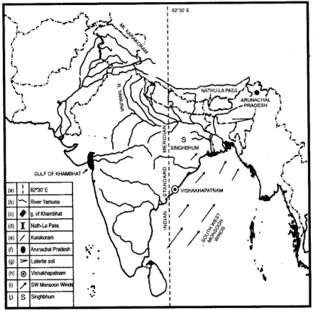
- Qstn #2On the outline map of India provided: (a) Mark and name Chennai (b) Label the river Godavari (c) Shade and label the Chhota Nagpur Plateau (d) Shade and name the Gulf of Kachchh
(d) Mark and name the Indo-Gangetic Plains
(d) Shade and label an area with Red Soil
(g) Mark and name the winds which bring rain to Mumbai in July and August (h) Mark and name the Satpura Range (i) Mark and name the Jharia Coal Field
(j) Shade and label the Northern Circar coastal regionAns :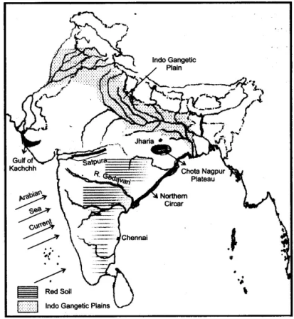
- Qstn #3On the outline map of India provided: (a) Draw, name and number the Tropic of Cance (b) Label the river Narmada (c) Shade and name Lake Chilka (d) Mark and name the Aravali Mountains
(d) Mark and name the Karakoram Pass
(d) Shade and name a densely populated state in South India (g) Shade and name a region with black soil
(h) Mark with a dot and name Srinagar (i) Mark and name the winds which bring rain in winter to the Coromandel Coast (j) Name and print O on an oilfield in North-east India.Ans :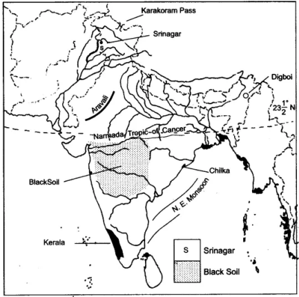
- Qstn #4On the outline map of India provided: (a) Mark and name Kochi. (b) Label the river Krishna. (c) Shade and label the Malwa Plateau. (d) Mark and label the Konkan Coast.
(d) Shade and label the Gulf of Mannar.
(d) Shade and label an alluvial soil area in Peninsular India.
(g) Mark with arrows the direction of the Arabian Sea branch of South West Monsoon Winds.
(h) Shade and label the Western Ghats. (i) Mark the Jharia coal field.
(j) Shade and name a densely populated area.Ans :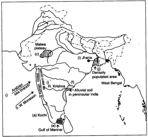
- Qstn #5On the outline map provided (a) Label the river Chenab. (b) Label the river Chambal. (c) Shade and label the Nilgiri Hills. (d) Mark and label the Eastern Ghats.
(d) Mark and name the port city of Pakistan.
(d) Mark and label Hyderabad.
(g) Shade and label the Sunderbans.
(h) Mark and name the Palk Strait. (i) Mark and label a region North of the Tropic of Cancer where tea is grown extensively.
(j) Mark and name the winds which bring rain to Mumbai in July and August.Ans :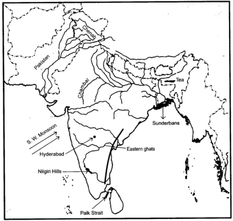
- Qstn #6On the outline map provided: (a) Shade and label the country Nepal. (b) Shade and label an area of black soil in India. (c) Mark and label the Konkan Coast. (d) Shade and label one region of winter rainfall in India.
(d) Sade and label the Sulaiman Ranges.
(d) Label the River Yamuna.
(g) Label the River Tapti.
(h) Shade and label the Vindhya Ranges.Ans :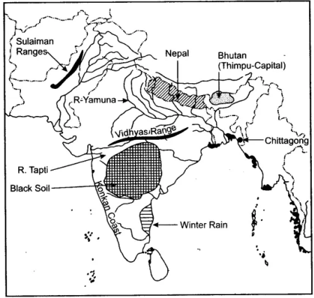
- Qstn #7Show the following on the outline map provided: (a) Shade and label the Satpura Range. (b) Label the River Krishna. (c) Label the River Ravi. (d) Shade and label the Khasi Hills.
(d) Mark with arrows the direction of the North-East Monsoon winds over the Bay of Bengal.
(d) Mark and label the Malabar coast.
(g) Shade and label an area of Laterite soil in India.
(h) Shade and label an area of Limestone in India.Ans :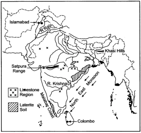
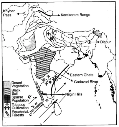
- Qstn #8On the outline map of the Indian sub-continent provided to you at the end of this question paper: (i) Mark with a bold line and label: (a) The Karakoram Range. (b) The Eastern Ghats. (c) The Nilgiris (ii) Shade and name one region for the : Black soil. (iii) Mark and label: (a) The Khyber Pass (b) The capital city of Assam. (c) River Godavari. (a) Identify, shade and name:
(1) A region of sparse population (less than 50 pp sq.) in North-Eastern India.
(2) A region of ‘Equatorial Forests’. (b) Mark with one long arrow, the direction of the Summer Monsoon over the Bay of Bengal.Ans :