ICSE-IX-Geography
13: Insolation
Note: Please signup/signin free to get personalized experience.
Note: Please signup/signin free to get personalized experience.
10 minutes can boost your percentage by 10%
Note: Please signup/signin free to get personalized experience.
- Qstn #8The vertical rays of the sun give more insolation than the slanting rays.Ans : Tropical region gets vertical rays of the sun and receive much heat providing high temperature while the temperate and polar regions have less temperature due to slanting rays of the sun.
- Qstn #9A desert region has a high range of temperature than a forest region.Ans : A desert region gets highly heated and quickly cooled down due to the sand cover; while the forested region most of the solar energy is used in transpiration in vegetation realm and do not become very hot. On the other hand due to the emission of carbon dioxide by plants the temperature is maintained due to the heat absorbing property of CO2.
- #Section : IVLong Answer Questions
- Qstn #1Describe the four factors that affect the distribution of temperature.Ans : The factors are different physical properties of land and water keeping continental climate cold and oceanic climate mild
- Latitude: The temperature decreases from the equator towards poles.
- Distance from the sea keeping coastal ports mild and areas for from sea cold. Altitude mountains are cooler than plains due to the lapse rate of decrease of temperature of 1°C for every 166 m. of height;
- Slope of the land: South facing slopes of mountains are warmer than northern facing. Inversion of temperature takes place in hilly valley regions due to higher sunny slopes and the valley downward covered with fog and snow are cooler than higher slopes.
- Wind direction: Windward slopes get much rainfall, while the Leeward slopes are drier. Natural vegetation cover absorbs 90% of solar energy, which is again consumed in transpiration and keeping the forested are mild, while snowy lands are cold.
- Cloud Cover and Humidity: Clouds reflect the sunlight leaving the land below cool. Still, the humidity absorbs heat keeping these areas with average temperatures not more than 30°C.
- Qstn #2Explain the effect of latitude and ocean currents on the temperature of a place.Ans : The Tropical areas are far warmer than the polar areas due to difference in the angle of incidence of the rays of the sun. Ocean currents greatly affect tire climate of a place or region e.g. the European western coast enjoy ice-free coasts and developed navigation due to the warm, effect of Gulf Stream - North Atlantic Drift, while the cold current of Benguala keeps the warm South African coast cool and mild.
- Qstn #3Describe the heat budget of the earth.Ans : Heat budget is actually the Heat Balance of incoming and outgoing radiation. The incoming solar radiation comes towards earth in short waves and provides heat to the earth as insolation in the day and again this insolation is given back by terrestrial radiation at night. This balance is called heat budget.
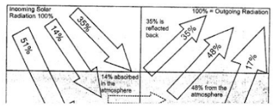
- Qstn #4State how the Global Heat Balance is achieved ?Ans : Out of 100 units of solar radiation 35 units are reflected back by atmospheric layers and clouds and snowfields etc. 14 units are absorbed by the ultra-violet rays in ozone layer and only 51 units are received by the earth as insolation and again these 51 units are reflected back by terrestrial radiation out of which 34 units are absorbed by the earth and sent back to atmospheric layers and 17 units radiated back into the space. This process is called the Heat budget or Global Heat Balance.
dlt2689126404491670993">
- Qstn #5With the help of a diagram, show the heat zones of the earth and write briefly about each of them.Ans :
Torrid Zone : It lies between 23 1/2° N and 23 1/2° S latitudes. This zone receives maximum temperature due to vertical rays of the sun and maximum rainfall.
Temperate Zone : It lies between 23 1/2° N - 66 1/2° N and 23 1/2° S - 66 1/2° S. It is known for medium temperature and rainfall due to slanting rays of the sun. 3.
Frigid Zone : It lies between 66 1/2° N - 90° N and to 66 1/2° S - 90° S. The sun’s rays are slanting and have to cover a very large distance. Besides this, inspite of long summer covering 6 months, the sun’s heat is immediately reflected back by the snow cover. So, the temperature is extremely low and cold Blizzards (icy winds) blow from Poles towards Arctic and Antarctic circles. The coldest place on the face of the earth is Varkhoyansk (-58°C) in N.E. Siberia. Although the temperature in Antarctic may be -94°C, but there is no habituated place, (as the definition of a place is the area inhabited by people).

- Qstn #6Study the table and answer the following questions : (1) Calculate the mean annual temperature (2) Calculate annual range of temperature (3) Name the hemisphere in which it is located. Give reasons to support your answer.
 Ans :
Ans :- 1. Sum of the temperature of hottest month of the year
= 4.4 + 10.0 + 13.3 + 16.0 + 15.0 + 10.0 + 5.0
= 73.7
Sum of the temperature of coldest month of the year = - (10.6 + 8.0 + 4.0 + 2.0 + 7.0)
= - 31.6
∴ Mean Annual temperature = {(73.7 + (-31.6)}/2
= (42.1)/12
= 3.5° C - Annual range of temperature = Highest temperature in a month of year - Lowest temperature in a month of year
= 16°C - 2°C = 14°C - It is located in Northern hemisphere: The Reason is due to the Earth’s Axial tilt, in the Northern hemisphere winter lasts from the winter solstice (typically December) to the March Equinox (typically March). While the summer lasts from the summer solstice (typically June) through the autumnal Equinox (typically September).
- 1. Sum of the temperature of hottest month of the year
- Qstn #7Name four factors that affect the temperature of a place.Ans : Four factors are
- Distance from equator
- Distance from sea
- Altitude from the sea-level
- Slope of the land.
- Qstn #8Describe world temperature patterns and its three chief characteristics.Ans : The world distribution of temperature generally shows a decreases in insolation from the Equator towards the poles. But this pattern is not everywhere the same. Three chief characteristics are the distance from the sea, physical properties of land and ocean (water), Height from the sea level.
- Qstn #9Explain the ranges of temperature and show their calculation.Ans : The Diurnal range is calculated by subtracting minimum temperature from the maximum temperature within 24 hours or of one day. The Mean monthly range is calculated by subtracting the mean minimum temperature from mean maximum temperature within 30 days or a month. Annual range of temperature is calculated by subtracting the mean minimum temperature from the mean maximum temperature within one year i.e. mostly between June and January.
- #Section : VPractical Exercises

- Qstn #2Calculate the mean annual temperature and annual range of temperature of the following station and name the hemisphere in which it is located.Ans : Mean annual temperature is 3.5°C.
The range of temperature is 20°C.
It is located in Northern hemisphere.